
Click: Here is a 2.5MB PDF file with a detailed map of the closure area.
Bottom line is that it’s not even close to Walker.
For Immediate Release- Due to increasing drought conditions, very high fire danger and public safety concerns, the Prescott National Forest will implement an area closure on the Bradshaw Ranger District Friday June 1st, 2018 at 8:00 AM. Areas outside of the closure will remain in Stage II Fire Restrictions.
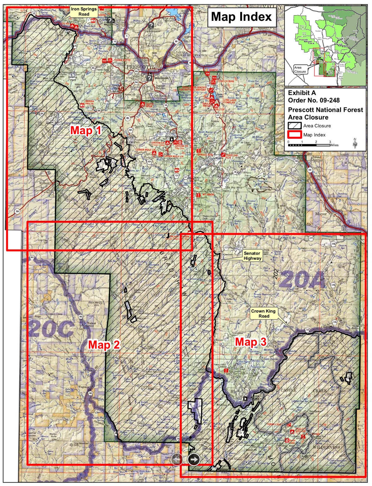
Bradshaw Ranger District Area Closure Description
Starting on the northwest corner of the closure area at the Prescott National Forest (PNF) boundary and County Road 10 (Iron Springs Road) intersection. Following County Road 10 north and east to the intersection of FSR 74 (County Rd 120, Skyline Drive). Following Forest Service Road (FSR) 74 south to non-motorized Trail 264. Following Trail 264 south and east to FSR 373 (Thumb Butte Road). Following FSR 373 south/southeast to FSR 9402C. Following FSR 9402C to the Mount Francis Non-Motorized Fuel Break. Following the Mount Francis Non-Motorized Fuel Break south/southeast to meet State Hwy 89 (White Spar Road). Following State Hwy 89 northeast to the junction of Indian Creek Road (County Rd 102). Following Indian Creek Road (CR 102) to National Forest/Ponderosa Park private property boundary. Following National Forest/Ponderosa Park boundary south then east to County Rd 101 (Ponderosa Park Road). Following County Rd 101 south to the junction of FSR 97B. Following FSR 97B south to FSR 667. Following FSR 667 south and east to FSR 9403C. Following FSR 9403C north and east to National Forest/private property boundary. Following the National Forest/private property boundary south and west to FSR 52B. Following FSR 52B to FSR 52 (Senator Hwy). Following FSR 52 south and east to County Rd 59 (Crown King Rd). Following County Rd. 59 north and east to the Prescott National Forest (PNF) boundary. Then following the PNF boundary south until it turns to the west. Then following the PNF boundary west until it turns north. Then following the PNF boundary north until it turns west again. Then following the PNF boundary west across the eastern intersection of County Road 60 and continuing to the western intersection of PNF boundary and County Rd. 60. Following County Rd. 60 north and west to the PNF boundary. Then following the PNF boundary north back to where it intersects with County Rd. 10 (Iron Springs Road).
Read the entire article at: https://www.fs.usda.gov/detail/prescott/news-events/?cid=fseprd581999


Leave A Comment