
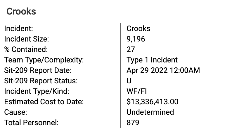
Note: $13,336,413.00!
Challenging fire but looking good
Location: 11 nautical miles south of Prescott-Bradshaw Ranger District (T12N, R2W, SEC 1), near Mt Union.
Start Date: April 18, 2022
Size: Approximately 9196 acres, 27% Containment
Cause: Under Investigation
Vegetation: Timber (Litter and Understory), Chaparral (6 feet)
Number of Personnel Assigned: 855
Since the fire started the challenge of strong winds has hampered firefighting efforts. Fire remains active in the Slate Creek drainage and the lower Crooks Creek drainage. Firefighters were able to control the spot that was an issue just west of Mount Tritle and continue to monitor the area for any activity. Fire in the southwest portion will have fuels transitioning to smaller and lighter brush which can assist with slowing the spread of the fire.
The northwest section of the fire contains a heavy timber fuel model with significant dead and down component contributing to increased fire behavior. Helicopters and fixed wing aircraft will continue operations throughout the day to slow advancement. The fire line boundary to the north is holding as crews continue with mop up operations. Despite these challenges, firefighters remain optimistic and are doing their best to get the upper hand on this fire. Overall, even though the fire has been challenging things are looking good.
WEATHER: On Friday and Saturday, high pressure will bring a continuation of very dry conditions, but lighter west to southwest winds.
SMOKE INFORMATION: Residents should be aware of increasing smoke conditions do to winds out of the south. Residents can monitor current conditions for the Crooks Fire, via Arizona Smoke Forecasting system located at https://azdeq.gov/wildfireforecast?fire=crooksfire
EVACUATIONS: Several areas remain in both the “READY” and ”SET” status. Residents should continue to monitor the Yavapai County Sheriff’s Department Facebook page for additional information. https://www.facebook.com/YavapaiCountySheriff/
FOREST CLOSURE: To provide public health and safety due to firefighting operations and fire danger
associated with the uncontrolled Crooks Fire, the Prescott National Forest has expanded the fire area emergency closure to the south. To view the Crooks Fire area closure order and map visit: Prescott National Forest – Alerts & Notices (usda.gov)Read the entire article at: https://www.facebook.com/PrescottNF


Leave A Comment