
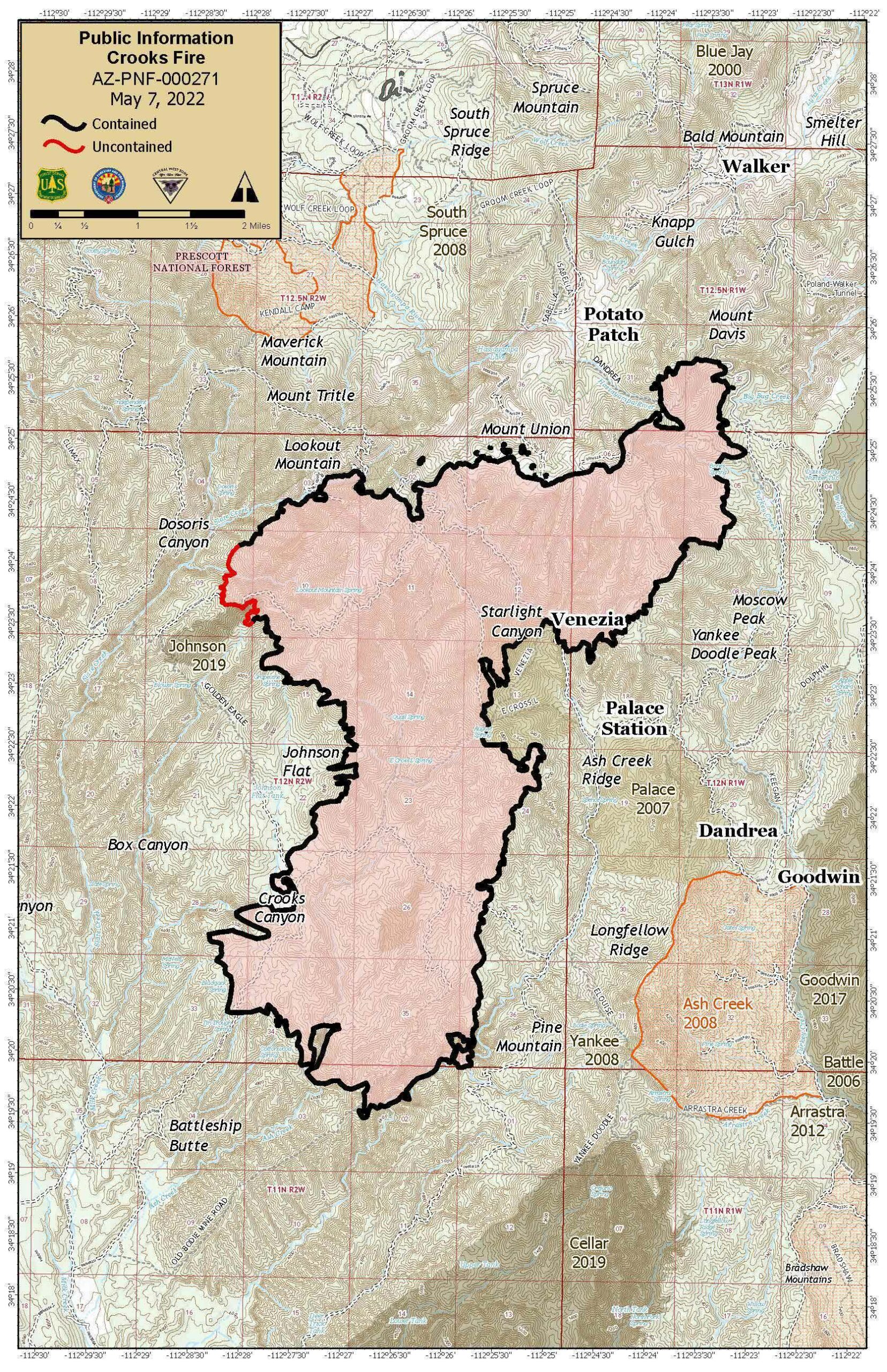
Location: 11 nautical miles south of Prescott-Bradshaw Ranger District (T12N, R2W, SEC 1), near Mt Union.
Start Date: April 18, 2022
Size: Approximately 9,402 acres
Percent Contained: 96%
Cause: Under Investigation.
Vegetation: Timber (Litter and Understory), Chaparral (6ft)
Number of Personnel Assigned: 276
The emergency closure area for the Crooks Fire has been reduced allowing for the opening of Upper Goldwater Lake and additional trails north of County Road 101, including portions of the Circle Trail and School House Gulch. Trails in Groom Creek and Spruce Mountain remain closed for public safety. All roads, trails and recreation sites including Upper and Lower Wolf Creek Campgrounds and Palace Station remain closed within the closure area.
Despite weather conditions yesterday, crews were successful keeping fire inside of exiting contained edges on the northern and eastern sides of the fire. Firefighters continue working to increase the depth of mop up operations along the fire’s uncontained northwest edge, working towards the interior to extinguish remaining pockets of heat.
Suppression repair work and chipping is near completion along Forest Service Road 97B and in the community of Potato Patch. We would like to remind residents driving in the area to utilize caution as fire traffic and personnel are still working in the communities of Potato Path, Walker, Lookout Mountain and Spruce Mountain.
Red Flag warnings continue today for Prescott. Crews will continue to stay vigilant during critical fire weather days and be prepared to assist in any initial attack efforts in the Prescott Basin if needed. Mount Union Lookout has been staffed to help monitor the fire area and notify fire personnel of any possible flair-ups that could cause concern along the fires edge; and monitor the southern portion of the Bradshaw Ranger District for any fire activity or smoke.
FIRE RESTRICTIONS: Fire restrictions are used to limit certain activities on public lands during periods of extreme fire risk. Fire restrictions have various levels called stages. Each stage limits specific activities and can vary from place to place, even those areas in close proximity. Know before you go on that trip to visit our national forests or public lands. Check on current fire restrictions at: WildlandFire.az.gov
WEATHER: Red Flag conditions will continue today due to very dry conditions and strong southwest winds. Winds with gusts of 40-45 mph are possible mid-afternoon.
FOREST CLOSURE: The Prescott National Forest has implemented a reduce fire area emergency closure on May 7, 2022, to provide public health and safety due to firefighting operations and fire danger associated with the uncontrolled Crooks Fire. Prescott National Forest Fire Closure Order and Fire Closure Map
A Temporary Flight Restriction (TFR) is in place: Wildfires are a NO Drone Zone. Flying recreational and media drones within a TFR is illegal and impedes fire suppression efforts. Report drones to local law enforcement. If You Fly, We Can’t.
Read the entire article at: https://www.fs.usda.gov/detail/prescott/news-events/?cid=FSEPRD1020049
Related Posts


About the Author: Conrad Walton
I’m Conrad Walton, a full time resident of Walker. We've lived through being snowed in and power outages.
We have no other home.
I'm a licensed real estate professional working for RealtyONEGroup, Mountain Desert, here in Prescott.
My goal is to give back to the community by providing a common web site to support everyone’s efforts in the Walker area.
Because I’ve been a web developer for over 20 years, building web sites is easy for me.
I want to help in any way I can.
This site is not owned by the WFPA or the WCAA or any other organization.
I host it, manage it, and I am completely responsible for it.
Leave A Comment