
We attended a briefing today at noon and got some information.
There was not a ton of information and we’ve been asked to go back for another briefing at 4pm. We were told the fire is at 6500 acres.
The blow up we saw yesterday was caused by erratic weather conditions.
The smoke right now appears to be more of a white-ish haze, not the churning darker smoke we saw yesterday. We should hope that the current haze persists.
The fire is in a lower and hotter location than Walker and today’s weather in Walker is good–cooler and more humid but wind could be an issue.
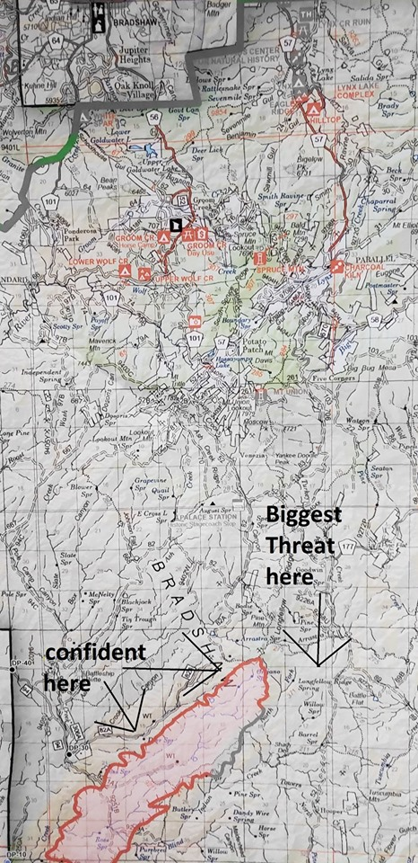
The air attack has been effective thus far on the Northwest flank, like inhibiting progression in that direction as indicated on the map. The impetus is for the fire to move eastward which creates the possibility of a run north along a wash into our area, this is the threat as shown on the map (link below).
The map is hard to read, we made it black and white except for where the fire is and where Walker is to hopefully provide context.
We will provide more after the next briefing along with another picture from Lookout Rock on Big Bug Mesa Rd.
https://walkerfire.org/wp-content/uploads/2019/07/cellar.png
The best source of updates will be the department’s Facebook page
https://www.facebook.com/walkerfiredept/
Thank you,
Roger Nusbaum
Fire Chief


Leave A Comment